|

|
|
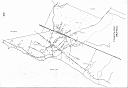
10. Kuokkala - beginning of 1930s
(GIF 1871*1293, 98796 bytes) |
11. Ollila - beginning of 1930s
(GIF 1260*1383, 69451 bytes) |
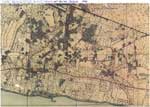
12. Terijoki map of 1932. Kindly presented by Leena Pullinen.
(JPG 1151*822, 204083 bytes) |
|
|
|
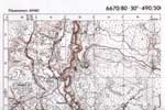
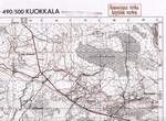
13. Kuokkala and Haapala. Fragment of Finnish military map of 1930s. Part 1. Kindly presented by Leena Pullinen.
(JPG 2251*1500, 370949 bytes) |
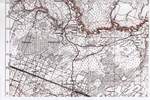
14. Kuokkala and Haapala. Fragment of Finnish military map of 1930s. Part 2. Kindly presented by Leena Pullinen.
(JPG 2251*1513, 456430 bytes) |
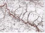
15. Kuokkala and Haapala. Fragment of Finnish military map of 1930s. Part 3. Kindly presented by Leena Pullinen.
(JPG 2258*1666, 356213 bytes) |
|
|
|
16. Kuokkala and Haapala. Fragment of Finnish military map of 1930s. Part 4. Kindly presented by Leena Pullinen.
(JPG 2258*1693, 378180 bytes) |
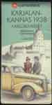
17. Karelian isthmus tourist map of 1938. The cover. Kindly presented by Leena Pullinen.
(JPG 826*1663, 61447 bytes) |
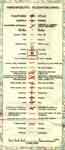
18. Karelian isthmus tourist map of 1938. The designations. Kindly presented by Leena Pullinen.
(JPG 833*1911, 90010 bytes) |


